項目簡介
Project Statement
西安“三河一山”綠道是由渭河,灞河及其支流浐河、庫峪河,灃河及其支流潏河、滈河,以及秦嶺環山帶共同組成的綠道網絡,線位長約312公里。
The "San He Yi Shan" greenway in Xi'an is composed of Weihe River, Bahe River (including its tributaries Chanhe River and kuyu River), Fenghe River (including its tributaries Feihe River and Yaohe River), and the shallow mountain area of Qinling Mountains, with a length of 312 km.

▼總體規劃范圍
Overall planning scope ?土人設計

“三河一山”綠道作為大西安核心區最重要的區域級綠道,以山、水、塬、田等生態因素為依托,連接鄉村和城市,串聯西安中心城區和周邊新城組團,沿途涉及11個區縣和開發區,體現了城市“背山面水、八水繞城”的山水格局,對市域生態環境的保護具有重要意義。
As the most important regional Greenway of Xi'an, "San He Yi Shan" is established by several ecological factors such as mountains, water, Tableland and farmland. It connects rural areas with urban areas, involving 11 districts and development zones. Greenway presents an ideal urban spatial pattern, which is of great significance to the protection of urban ecological environment.

目標與挑戰
Site and Challenges
“三河一山”綠道以“維護大西安生態安全、體驗西安山水文化魅力、滿足人民對美好生活的向往”為目標,堅持以“保護為主、修復為輔、合理利用”為原則,采用生態優先的“逆向規劃”理念來保護綠道沿線河流、森林、濕地、農園和文化遺產,這些關鍵空間將形成一個生態基礎設施來解決綠道沿線的水系調節問題,留住城鄉空間的生物棲息地,保護傳承歷史文化遺產,解決人們日常休憩問題和留住關中鄉愁。
The "San He Yi Shan" greenway aims to "maintain the ecological security of Xi'an, experience the charm of Xi'an's landscape culture, and meet the people's expectation for a better life". It complies with the principle of "protection first, restoration second, then rational utilization", and adopts the concept of "reverse planning" of ecological priority to protect the rivers, forests, wetlands, agricultural gardens and cultural heritage along the greenway. These key spaces will come into an ecological infrastructure to solve the problem of water regulation and retain the biological habitat of urban and rural space, protect and preserve the historical and cultural heritage, provide public place and retain homesickness.

“三河一山”綠道規劃與建設面臨以下六大挑戰:
挑戰一:水系統保水、自凈能力不足。現狀河流以防洪為主要功能,城市用水激增和源頭水土流失,造成旱季缺水,水質受到威脅。
挑戰二:沿線生境退化。河流駁岸硬化治理、沿岸林帶破壞、抬高水面淹沒河流洲島等做法,造成沿線動物棲息地退化甚至消失。
問題三:鄉土景觀逐漸消失。精致的、高維護的植被搭配景觀向秦嶺北麓蔓延,作為曾經的關中糧倉,秦嶺北麓的鄉土景觀正在逐漸消失。
問題四:歷史文化遺存保護利用不當。沿線遺存豐富,目前以文保單位為主的搶救性保護方式無法全面、有效地保護和展示文化遺產價值。
問題五:游憩資源聯動發展不足。” 現有游憩資源分散,品質參差不齊,產業聯動效應弱。
問題六:可達性、連續性、體驗性差。濱河及秦嶺沿山區域現有騎行道和步行道可達性和連續性差,出行安全性和體驗性差。
The planning faces the following six challenges:
(1)The capacity of water conservation and water system self purification is insufficient.
At present, the main function of rivers is flood control. Due to the surge of urban water use and soil erosion at the source, water shortage and water quality are threatened in dry season.
(2)Habitat degradation.
Hardened riverbanks, destroyed vegetation and submerged islands have resulted in the degradation or even disappearance of animal habitats.
(3)The vernacular landscape gradually disappeared.
High maintenance landscape is spreading to the Qinling Mountains, and the local landscape of Qinling shallow mountain area is gradually disappearing.
(4)The protection and utilization of existing cultural relics are not appropriate.
There are abundant relics along the greenway. However, the emergency method of historical and cultural sites under government protection can not fully and effectively protect and display the value of cultural heritage.
(5)The interactive development of recreational resources is insufficient.
The existing recreational resources are scattered, the quality is varied, and the business interaction is weak.
(6)Accessibility, continuity and experience are required to be improved.
The accessibility and continuity of the existing cycling and walking roads in the riverside and Qinling Mountains are unsatisfied, and the safety and experience are required to be improved.
▼健康的水系廊道
Healthy water corridor ?土人設計

設計策略
Design Strategies
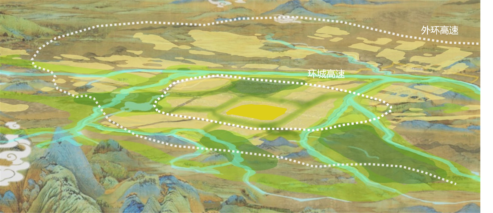
策略一:構建一條呈現多彩自然的生態廊道。
針對綠道水文調節、生物棲息、遺產保護、休閑游憩等功能進行研究分析,構建綜合生態安全格局,與用地規劃進行協調,形成區域生態基礎設施。依托生態基礎設施劃定綠道生態控制區,對綠道保護、修復和利用進行管控和建設引導。
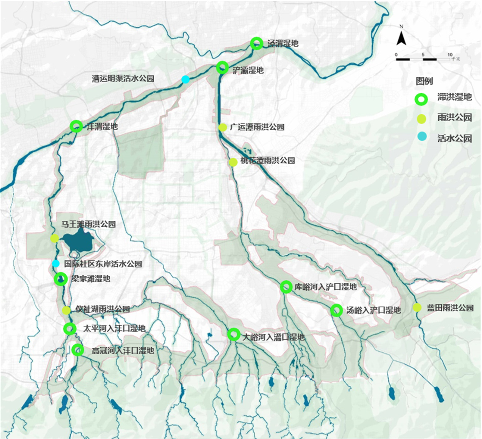
通過規劃和提升滯洪濕地、雨洪公園,設立污水處理廠試點活水公園,修復數十公里生態岸線和森林帶,整合提升秦嶺山塬的特色農園,實現河流廊道、沿線鄉土生境和優質農林資源的保護、修復與利用,展現秦嶺北麓的綠水青山和豐饒大地。
策略二:營造一條體驗古都山水文化的遺產廊道。
圍繞“中華文明的開放與包容”這一主題,以古運河和古驛道兩類線性文化遺產為主要對象 ,借助綠道串聯周邊文化遺址和鄉土文化遺產,完善遺產廊道上相關遺存的保護與展示,讓文化遺產走進人們生活。
策略三:打造一條為人民創造更美好生活的幸福廊道。
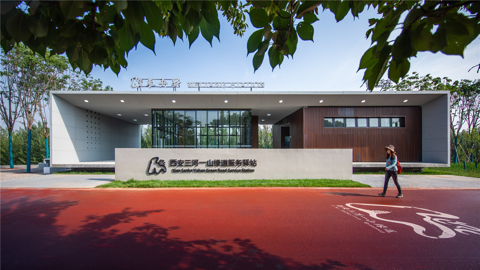
充分利用現狀堤頂路、風景優美的低等級鄉村道路,貫通、提升410KM綠道主游徑,規劃多樣化的支游徑,引入自行車、馬拉松等賽事活動和其他文化娛樂活動。落實三級驛站服務體系,引入智慧管理系統,提供休息、智慧解說、安保、換乘和娛樂服務。串聯沿線100多個游憩點,與周邊城市商業中心、特色小鎮、旅游景區和工業遺址區進行聯動發展,提供豐富的生活休閑體驗。
(1)Build a colorful and natural ecological corridor.
To build a comprehensive ecological security pattern, then coordinate with land use planning, and finally create a regional ecological infrastructure.
Based on the ecological infrastructure, the greenway ecological control area is delimited to control and guide the greenway protection, restoration and utilization.
By protecting the wetland, establishing the living water park and protecting the shoreline, the river corridor can be restored. The integration and upgrade of agricultural parks help achieve the promotion of high-quality agricultural and forestry resources.
(2)Build a heritage corridor to experience the landscape culture of the ancient capital.
The theme of Greenway is open mind. It mainly connects two types of linear cultural heritage: canal and post road, and protects and displays the relevant remains, so as to let the cultural heritage step into people's life.
(3)Build a happy corridor to create a better life for the people.
Make full use of the existing riverbank roads and beautiful rural roads to connect the main travel path of the 410km greenway, and introduce cycling, marathon and other cultural and entertainment activities. The greenway has set up three-level post service system and introduced intelligent management system to provide diversified services. It not only connects lots of recreational spots, but also develops with the surrounding areas.
▼運河遺產資源
Canal Heritage Resources ?土人設計

▼古驛道遺產資源
Ancient post road heritage resources ?土人設計

▼“三河一山”綠道游徑系統圖
"Three rivers and one mountain" greenway trail system diagram ?土人設計

▼“三河一山”綠道驛站系統圖
System diagram of "three rivers and one mountain" greenway post station ?土人設計

▼環西安大公園游憩帶項目落點圖
Location map of recreation belt project around Xi'an Grand Park ?土人設計

▼”一環、四帶、十四段“
”First ring, fourth belt and fourteenth section“ ?土人設計

03.結論
Conclusion
西安“三河一山”綠道將會成為環繞大西安核心區的超級綠道。從灞橋遺址作為起點,經灞河、渭河、灃河到儀祉湖,將形成一條長74km、全線騎行不下車的精品段,將會為市民和游客提供獨特的出行體驗。“三河一山”綠道將成為西安綠色發展的生態名片,展現西安山、水、城相融的美麗城市。
The "San He Yi Shan" Greenway will become a grand around in the core area of Xi'an. It is a 74 km long, barrier free greenway from Baqiao site to Yizhi lake, which will provide unique travel experience for citizens and tourists. "San He Yi Shan" greenway will become the ecological card of Xi'an's green development, showing the beautiful city of Xi'an with mountains, water and city.


項目信息
項目名稱:陜西省西安市“三河一山”綠道詳細規劃及重點區域城市設計
委 托 方:西安市自然資源和規劃局
項目地點: 陜西省西安市
項目規模:730平方公里(規劃范圍),25平方公里(重要區域設計范圍)
首席設計師:俞孔堅
設計部門:海綿城市建設分院
項目負責人:林雙盈
設計團隊:林雙盈、王櫟、韓俊龍、方圓、黃超、熊瑋佳、葉慶龍、郭璇、關舒、劉茵宸、李源、彭川、王嬌、唐蘇微、常鑫、武超、肖京澤、崔曉雷、毛睿、楊洋、王天霞、王國威、楊學賓、張潔、袁開文
Project Name:DETAILED PLANNING OF "SAN HE YI SHAN" GREENWAY AND URBAN DESIGN OF KEY AREAS IN XI'AN, SHANXI PROVINCE
Client:Xi 'an Natural Resources and Planning Bureau
Location:Xi 'an City, Shanxi Province, China
Design : Turenscape
版權聲明:本文版權歸原作者所有,請勿以景觀中國編輯版本轉載。如有侵犯您的權益請及時聯系,我們將第一時間刪除。
投稿郵箱:info@landscape.cn
項目咨詢:18510568018(微信同號)
 京公海網安備 110108000058號


 北京海淀區
北京海淀區
 www.turenscape.com
 turen@turenscape.com
